
The Warehouse State: Diesel, Distribution, and a Gap in New Jersey's Environmental Justice Law
Abstract. New Jersey now has more than a billion square feet of warehouse and distribution space. These buildings emit almost nothing from their own smokestacks, but they attract a steady stream of diesel trucks, and they are not covered by the state’s landmark Environmental Justice Law. A bill introduced in January 2026 (A2740/S2339) would create an “indirect source” permit that requires high-traffic warehouses to cut truck emissions to zero by 2050. Using OpenStreetMap building footprints, I identified 3,594 large (50,000+ sq ft) warehouse and industrial buildings. My count closely matches a 2024 estimate based on a commercial real estate database: 2.7 million New Jerseyans (29%) live within half a mile of one. Residents of overburdened communities are 3.1 times as likely as other residents to live that close. Block groups with more warehouse space nearby have higher truck traffic and diesel cancer risk in NJDEP’s own data. Of the buildings I identified, 2,930 would meet the bill’s size thresholds, including 1,105 mid-size buildings covered only because they sit in overburdened communities.
1. From Garden State to Warehouse State
The Port of New York and New Jersey is one of the busiest container ports in the country, and it sits at the center of the densest consumer market in the United States. Those facts, together with the rise of e-commerce, have turned New Jersey into one of the nation’s largest warehouse markets. A 2025 study by Rutgers’ Center for Advanced Infrastructure and Transportation counted about 1.02 billion square feet of warehouse and distribution space in buildings of 20,000 square feet or more, nearly 956 million of it occupied, supporting about 764,000 on-site workers (NJBIZ, 2025). Warehouses are now visible across the state, from the Meadowlands to the farm fields along Turnpike Exit 8A to the Route 295 corridor in Gloucester and Salem counties.
The economic benefits are real. The environmental costs depend on what moves in and out of the buildings. A large distribution center can generate hundreds or thousands of truck trips per day, and most of those trucks still burn diesel. Diesel exhaust is classified as a known human carcinogen (Group 1) by the International Agency for Research on Cancer (IARC, 2012). It also contains fine particles and nitrogen oxides that worsen asthma and heart disease. A comprehensive review by the Health Effects Institute (2010) concluded that the evidence is “sufficient” to link traffic-related air pollution to worsening asthma, with the strongest effects within roughly 300–500 meters of major roads.
2. A gap in the law
New Jersey’s Environmental Justice Law, discussed in Post 1, covers eight types of facilities, including major air pollution sources, incinerators, landfills, and scrap yards. Warehouses are not on the list. A warehouse is usually not a “major source” of air pollution, because the trucks that serve it are mobile sources regulated mostly by federal vehicle standards, not by facility permits. Under conventional permitting, a warehouse can therefore draw heavy diesel traffic into a neighborhood without triggering any air permit at all.
Regulators call facilities like this indirect sources: places that do not pollute much themselves but attract pollution. The federal Clean Air Act allows states to regulate indirect sources. California’s South Coast Air Quality Management District adopted the first major warehouse rule in 2021 (Rule 2305). It requires warehouses of 100,000 square feet or more to earn “points” each year by taking actions such as buying zero-emission trucks, installing chargers, or adding solar panels. In December 2023, a federal judge rejected the trucking industry’s argument that the rule was preempted by federal law, and in September 2024 the U.S. EPA approved it into California’s federally enforceable air quality plan (Transport Topics, 2023; Arnold & Porter, 2024).
New Jersey’s version is A2740/S2339, introduced in January 2026 and referred to the Assembly Environment and Solid Waste Committee. As introduced, the bill would (New Jersey Legislature, 2026):
- require an indirect source air pollution permit from NJDEP for goods distribution facilities of 100,000 square feet or more, or 50,000 square feet or more in an overburdened community, and for any facility (including ports) that generates 50 or more truck trips per day;
- set a goal of reducing emissions from these facilities to zero by 2050, through annual “points obligations” earned with electric trucks, chargers, solar and storage, air filtration in nearby schools, and similar measures;
- make obligations 25% higher for facilities near ports or overburdened communities, shorten permit terms there (three years instead of five), and double inspection rates; and
- let community members petition NJDEP to review permits, with penalties of up to $20,000 per day for violations.
Supporters argue that the bill closes the largest remaining gap in New Jersey’s environmental justice framework (Earthjustice, n.d.). Business groups have generally argued that existing laws are sufficient and that new mandates raise costs. As of early November 2026, I could find no record of committee action on the bill.
3. Mapping New Jersey’s large warehouses
Public data on warehouses is surprisingly hard to find. The best-known estimate, a 2024 report by the Environmental Defense Fund (EDF) and partners, relied on a private real estate database. It found 3,034 warehouses of 50,000+ square feet and estimated that about 2.7 million people (roughly one in three) live within half a mile of one, the highest rate of any state the group had studied (EDF, 2024). I wanted to test whether that finding could be reproduced with fully open data, so that anyone can check it. Full code and methods are in code/.
Building the inventory. OpenStreetMap (OSM) contains footprints for more than a million New Jersey buildings, but few large buildings are explicitly tagged as warehouses. I therefore defined a transparent proxy. I kept every building with a footprint of at least 50,000 square feet that is either (a) tagged as a warehouse or industrial building, or (b) mostly located on land mapped as industrial, railway, or port, with no shop or amenity tag. I excluded stores, schools, hospitals, offices, housing, and parking structures. This produced 3,594 buildings with about 590 million square feet of combined footprint, 1,825 of them 100,000 square feet or larger. That is close to EDF’s 3,034, though my proxy includes some factories along with warehouses.
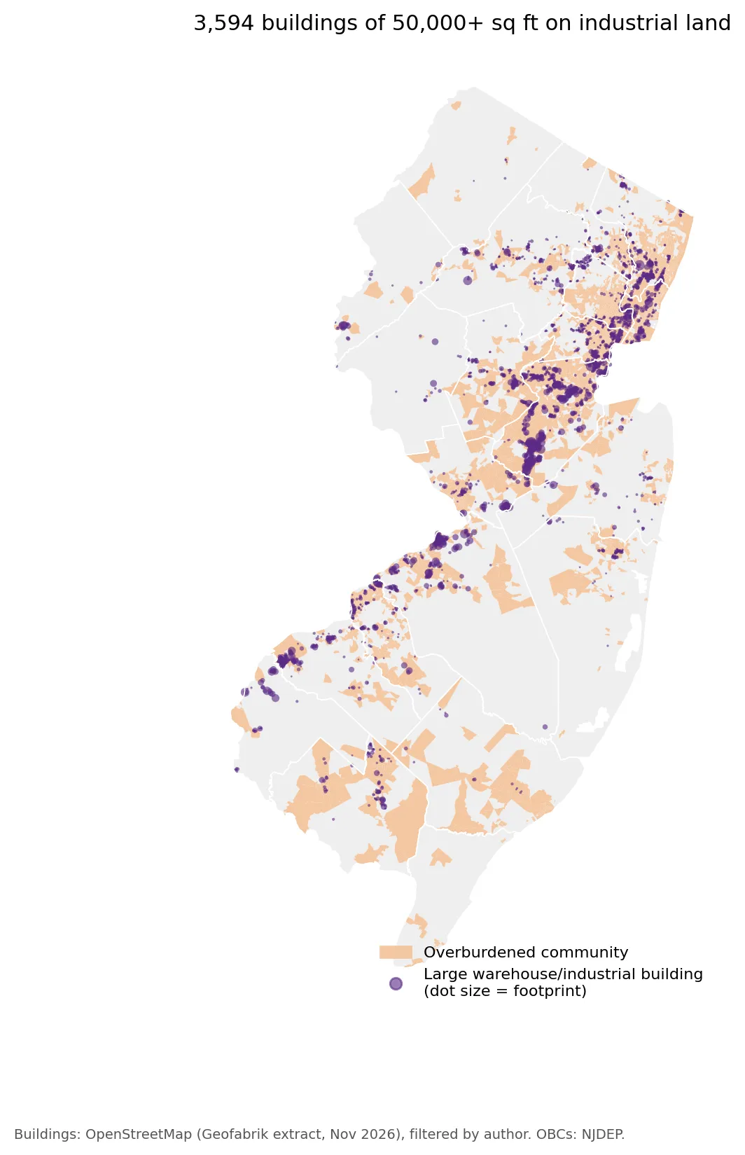 Figure 1. Large warehouse and industrial buildings (purple) and overburdened communities (orange).
The map (Figure 1) shows the familiar geography of New Jersey freight: a dense band along the Turnpike from Bergen through Hudson, Essex, and Union counties to the Port; a massive cluster in central Middlesex County, which alone has 178 million square feet of footprint; and a growing southern corridor along the Delaware River in Burlington and Gloucester counties.
4. Results
Who lives near large warehouses?
Using 2020 Census population for 138,000 census blocks, I counted residents within half a mile of these buildings (Figure 3):
| Within 1/2 mile of a 50,000+ sq ft building | Within 1/2 mile of a 100,000+ sq ft building | |
|---|---|---|
| All New Jersey residents | 2.69 million (29.0%) | 1.90 million (20.4%) |
| Residents of overburdened communities | 2.17 million (40.7%) | 1.56 million (29.2%) |
| Other residents | 0.53 million (13.3%) | 0.34 million (8.7%) |
| Ratio (OBC ÷ other) | 3.1× | 3.4× |
With entirely open data, I arrived at nearly the same statewide total as EDF’s commercial-data analysis (2.69 million vs. about 2.7 million). That agreement gives some confidence in both estimates. The disparity is large: about two in five residents of overburdened communities live within half a mile of a large warehouse or industrial building, compared with one in eight other residents.
 Figure 3. Share of residents living within half a mile of a large warehouse or industrial building, by overburdened community status.
Do warehouses show up in the pollution data?
NJDEP’s environmental justice dataset measures heavy-duty truck traffic and diesel particulate cancer risk for every block group. If warehouses really attract diesel trucks, block groups near more warehouse space should score higher on both. They do (Figure 2).
| Warehouse footprint within 1 km | Block groups | Median heavy-truck traffic | Median diesel PM cancer risk (per million) | Share that are OBCs |
|---|---|---|---|---|
| None | 2,817 | 418 | 0.20 | 41% |
| Lowest quarter | 935 | 834 | 0.28 | 58% |
| 2nd quarter | 936 | 1,033 | 0.33 | 67% |
| 3rd quarter | 941 | 1,103 | 0.35 | 73% |
| Highest quarter | 917 | 1,808 | 0.30 | 75% |
Median heavy-truck traffic rises more than fourfold, from 418 in block groups with no large warehouses nearby to 1,808 in those with the most. Diesel cancer risk rises by about half before leveling off. The correlations are modest (Spearman’s ρ = 0.21 for trucks and 0.33 for diesel PM), which is expected, because highways, ports, and rail yards also generate truck traffic. Still, the pattern is consistent with warehouses acting as indirect sources. The share of block groups that are overburdened communities also climbs steadily with warehouse exposure, from 41% to 75%.
 Figure 2. NJDEP heavy-duty truck traffic and diesel PM cancer risk, by warehouse footprint within 1 km of each block group.
What would A2740/S2339 cover?
The bill’s truck-trip threshold cannot be tested with public data, but its size thresholds can. Of the 3,594 buildings in my inventory:
- 1,825 are 100,000 square feet or larger and would be covered anywhere in the state; 63% of these are in or adjacent to an overburdened community.
- 1,105 more are mid-size buildings (50,000–99,999 sq ft) that would be covered only because they are in overburdened communities. The bill’s lower threshold in those communities would expand coverage by about 60%.
- Overall, 61% of large warehouse and industrial floor area sits in overburdened communities, which cover just 24% of the state’s land.
In other words, the bill’s overburdened-community provisions are not a minor detail. They decide whether more than a thousand facilities are regulated.
5. Limitations
- A proxy, not an official inventory. My building set includes some factories, misses warehouses not mapped in OSM, and measures footprint, not total floor area. It identifies large buildings on industrial land; it does not know what each building does or how many trucks it serves.
- Proximity is not exposure. Living within half a mile of a warehouse does not by itself measure the pollution a person breathes. Truck routes, wind, and building design all matter.
- The OBC definition is broad. Some suburban warehouse corridors, especially in Middlesex County, are overburdened communities largely because of the 40% minority criterion, which includes many middle-income Asian American and Latino neighborhoods. That reflects the law’s definition, but readers should not assume every OBC near a warehouse is low-income.
- Correlation. The link between warehouse space and truck/diesel stressors is cross-sectional. Highways, ports, and industrial zoning cluster together, so warehouses are not the only cause.
6. Conclusion
New Jersey’s warehouse boom has created a large and unevenly distributed exposure that the state’s Environmental Justice Law was not designed to address. Open data confirm the headline finding of earlier research: nearly 2.7 million residents live within half a mile of a large warehouse, and residents of overburdened communities are about three times as likely to be among them. A2740/S2339 would treat these buildings as what they functionally are, pollution magnets, and would apply the strongest requirements where the burden is greatest. Whether it becomes law will shape the air in many of New Jersey’s most burdened neighborhoods for decades.
Data and methods
The analysis was done in Python with public data. The full code, its data, and every figure it produces are in the code project below.
References
- Arnold & Porter. (2024). EPA approves South Coast Air Quality Management District's warehouse indirect source rule. https://www.afslaw.com/perspectives/environmental-law-advisor/epa-approves-south-coast-air-quality-management-districts
- Earthjustice. (n.d.). Diesel damage: How warehouse sprawl is sickening two states. https://earthjustice.org/article/indirect-source-rule-new-york-new-jersey
- Environmental Defense Fund. (2024). New Jersey's warehouse boom [Report with Clean Water Action and partners]. https://cleanwater.org/sites/default/files/2024-06/NJ-Warehouse-Boom-Report-EDF-6-14-2024.pdf
- Geofabrik GmbH & OpenStreetMap contributors. (2026). New Jersey OpenStreetMap extract [Data set]. https://download.geofabrik.de/north-america/us/new-jersey.html
- Health Effects Institute. (2010). Traffic-related air pollution: A critical review of the literature on emissions, exposure, and health effects (Special Report 17). https://www.healtheffects.org/publication/traffic-related-air-pollution-critical-review-literature-emissions-exposure-and-health
- International Agency for Research on Cancer. (2012). IARC: Diesel engine exhaust carcinogenic (Press Release No. 213). World Health Organization.
- New Jersey Department of Environmental Protection. (2026). Environmental Justice (EJ) Law Combined Stressor Summary (Current) [Data set].
- New Jersey Legislature. (2026). Senate Bill No. 2339 / Assembly Bill No. 2740: An act concerning indirect air pollution from certain facilities. https://pub.njleg.gov/Bills/2026/S2500/2339_I1.HTM
- NJBIZ. (2025, November). NJ warehouses drive $295.8B economic impact [Report on Rutgers CAIT study]. https://njbiz.com/nj-warehouses-distribution-centers-economic-impact/
- Transport Topics. (2023, December). California pollution rule aimed at logistics upheld by judge. https://www.ttnews.com/articles/california-logistics-pollution
- U.S. Census Bureau. (2021). TIGER/Line shapefiles: 2020 tabulation blocks, New Jersey (with 2020 population) [Data set].